
(Maritime Manuscript) | A beautfully illustrated compendium by a student at the Royal Naval Academy at Portsmouth
Lot Closed
December 8, 09:00 PM GMT
Estimate
10,000 - 15,000 USD
Lot Details
Description
(Maritime Manuscript) — Thomas Whichcote
"A Plan of Mathematical Learning Taught in the Royal Academy Portsmouth. Performed by Thomas Whichcote, a Student there." Portsmouth, England, 27 April 1804
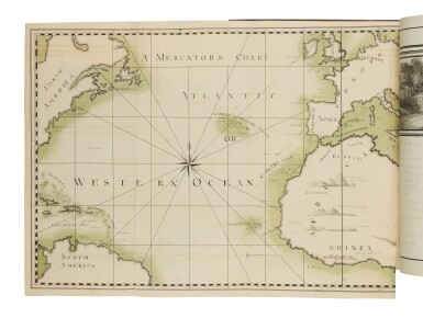
Folio (363 x 264 mm). 509 pages written in a fine, clear cursive hand, illustrated with 10 half-page and 2 full-page ink wash illustrations, one half-page and one full-page pen and ink drawings, and 10 half-page watercolors, all land- or seascapes; also with eight full-page maps and one folding map, all in color; 5 full-page black and white diagrams, 11 full-page color diagrams, and numerous diagrams in the text, some heightened with color; folding map with two-inch tear along a fold, just touching the edge of the image, last two leaves with slight soiling and fraying to fore edges, isolated minor thumbing, small stains, and other trivial imperfections, but withal in fine preservation. Attractive contemporary mottled calf, very skillfully rebacked to style, flat spine gilt in panels formed by multiple plain and decorative rules and with whirling floral centerpiece, red morocco label; corners a little bumped, spine a bit dry and crackled with a couple of one-inch chips, minor loss of gilt.
A beautifully executed compendium of mathematical knowledge necessary for an officer in the Royal Navy, written and illustrated by a student at the Royal Naval Academy at Portsmouth, which was founded to recruit and train officers from among the many qualified young men who lacked the family connections otherwise to obtain a naval commission. The volume covers arithmetic, geometry, plane trigonometry, geography, navigation (at one hundred pages, by far the longest section), spherics, spherical trigonometry, astronomy, latitude, longitude, marine surveying, fortification, gunnery, and mechanics.
The text is neatly written in a very skilled and controlled hand, and examples of calculations are given, but the illustrations are the most notable feature of the manuscript. Whichcote was a talented artist, and while at the Royal Naval Academy, he would have had the opportunity to study with noted marine artist Richard Livesay (1750–1826), who served as drawing master there from 1796 to 1811. The ink washes and watercolors here portray not only ships and scenes at sea, but also several fine landscapes, including a full-page view of the Portsmouth Academy. The fine maps show Christmas Island, the Coast of Kamchatka, Table Bay and the Cape of Good Hope, the western Atlantic with the coastline of North America and the West Indies, and the eastern Atlantic with the coast of Africa, Ireland, Greenland, and Iceland.
PROVENANCE:
Thomas Whichcote (inscription on front free endpaper, “Thomas Whichcote, Esq., of His Majesty’s Ship ye Beaulieu of 44 Guns”)


