
Electric and International Telegraph Company | Map of Europe ... shewing the system of Telegraphs, 1859
Lot Closed
May 13, 01:44 PM GMT
Estimate
800 - 1,200 GBP
Lot Details
Description
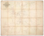
Electric and International Telegraph Company--Waterloo & Sons
Map of Europe compiled from the most recent surveys published for the Electric & International Telegraph Company, shewing the system of Telegraphs with which they are connected. London: Waterloo & Sons, 1859
Large folding tinted lithographed map (765 x 913mm.), dissected and backed on linen, some pencil annotations about the cables on the map, slight toning and wear
A RARE TELEGRAPH MAP depicting the telegraph lines in red connecting Great Britain and Ireland to Continental Europe extending to Moscow and Constantinople in the East and to Tunisia and Algeria in North Africa. The pencil annotations, presumably written for the Director General's Office (see provenance) include notes on which cables have broken down.
PROVENANCE:
Government Telegraph Dept., Director General's Office, European lines (ink inscription on reverse of the map and pencil annotations on the map)


